JOURNAL OF CONSTRUCTION: BIM, GIS, AND DIGITAL TWINS ONLY DELIVER VALUE WHEN EXISTING-CONDITION DATA IS RELIABLE
In urban railway projects, technology is not the root cause of risk. Most technical conflicts, quantity overruns, and design revisions trace back to one common cause: existing-condition data that does not fully reflect current structures and technical infrastructure. According to Mr. Tran Phuc Minh Quang, Deputy General Director of PORTCOAST, even the most complete BIM model, GIS system, or Digital Twin loses its meaning if the input data does not reflect reality. This is why the world is shifting its focus from “digitizing records” to “digitizing existing conditions.” Applying Reality Capture technologies such as UAVs and laser scanning enables accurate 3D as-is modeling, early conflict detection, and effective control of quantities and costs. More importantly, data must be inherited throughout the lifecycle via a Common Data Environment (CDE), so that BIM becomes a platform for asset management rather than merely a design tool. Existing-condition data is not just an input for design — it is the foundation of the entire project lifecycle. Done right from the start, its value is harnessed for decades.
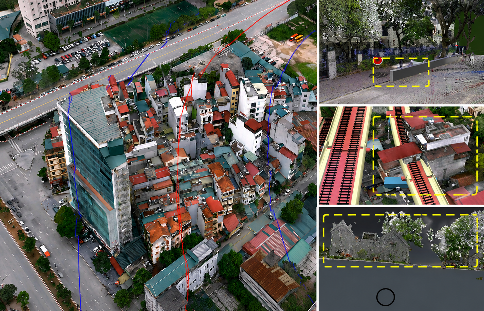
Urban existing-condition data is digitized to identify early risks of conflicts between new works and existing infrastructure.
When discussing digital transformation in the transportation sector, most conversations often focus on BIM, GIS, Digital Twins, or artificial intelligence (AI). However, from experience in metro, urban transport, and large-scale infrastructure projects, most technical and project-management risks do not originate from technology itself, but from the quality of existing-condition data.
A BIM model can be developed in great detail. A GIS system can integrate many data layers. A Digital Twin can simulate many operational scenarios. But if the input data does not accurately reflect reality, all the technology layers behind it will lose their meaning. This is why many project owners around the world are shifting their focus from digitizing documents to digitizing existing conditions.
Many project risks appear before design begins
Practical experience from urban railway projects around the world shows that the greatest difficulties are usually concentrated in 5 groups of issues: (i) Shortage of existing-condition data, including topographic data, geological data, underground utility infrastructure, and as-built records; (ii) Design conflicts between disciplines or between new works and existing structures; (iii) Issues related to site clearance, permits, and coordination among multiple management agencies; (iv) Risks arising during construction because actual conditions differ from design assumptions; (v) Loss or interruption of data when transferring from the investment and construction phase to the operation and exploitation phase.
It is worth noting that most technical risks in transportation infrastructure projects are directly related to the quality of input data. Many major urban railway projects around the world, such as Sydney Light Rail (Australia), Crossrail - Elizabeth Line (United Kingdom), California High-Speed Rail (United States), Marmaray (Turkey), Stuttgart 21 (Germany), and Delhi Metro (India), have all faced challenges related to existing-condition data, technical conflicts, or asset information during the handover to operation.
If a road is built on vacant land, existing-condition data mainly relates to topography and geology. But for urban metro projects, especially underground metro lines, the level of complexity is completely different. New works must exist in an environment that has already been built and operated for decades. Beneath the ground are water supply systems, drainage systems, power networks, telecommunications, underground cables, building foundations, and many other technical infrastructure systems. Above the ground are residential buildings, commercial structures, urban traffic, and works that need to be preserved.
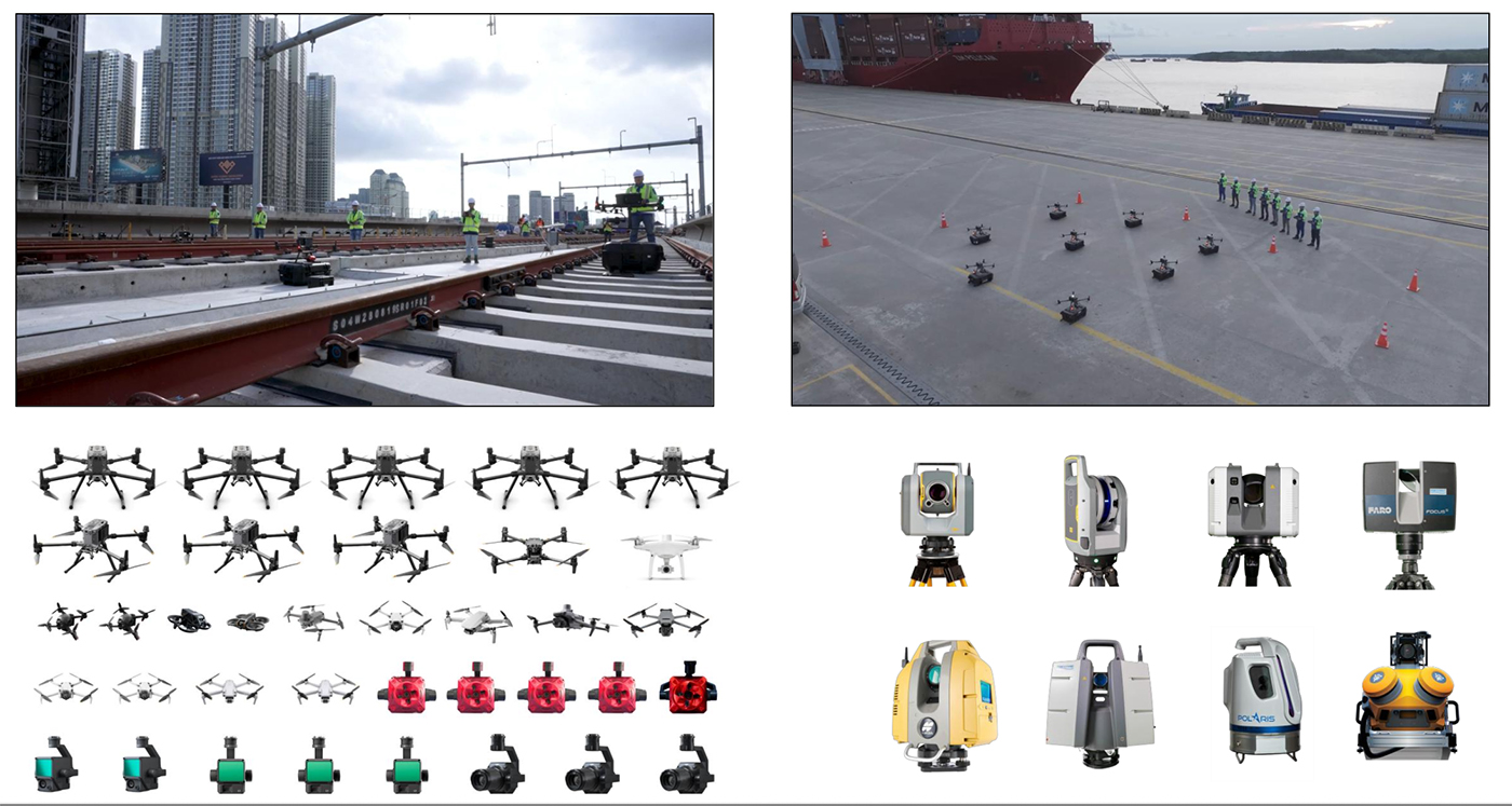
UAV, laser scanning, and digital surveying equipment are used to collect existing-condition data of works.
Several urban railway projects in Hanoi and Ho Chi Minh City show that surveying and developing existing-condition models have become an inseparable part of the design process. Existing-condition data not only supports alignment-option selection but also helps identify technical conflict risks at an early stage.
In some cases, digital models help identify early risks of conflicts between new works and transport infrastructure, existing structures, or areas that need to be preserved.
From as-built records to a digital model of the city
One of the biggest challenges of metro projects is accurately identifying the locations of existing underground technical infrastructure. In practice, existing-condition data in many cities has been formed through different stages of development, leading to differences in standards, coordinate systems, and levels of information updating. In addition, in dense urban environments, a deviation of only a few dozen centimeters can create significant consequences for underground works.
To solve this problem, Reality Capture technologies are being applied more widely. Accordingly, existing-condition data is collected by UAV, terrestrial laser scanners, mobile scanning devices, and modern surveying systems. This data is then processed into point cloud models, digital terrain models, and 3D existing-condition models.
For metro projects, existing technical infrastructure systems are digitized into three-dimensional models from as-built records combined with field survey data. As a result, cables, pipelines, and underground works no longer exist as separate drawings, but become part of a unified data environment.
When the existing-infrastructure model is integrated with the design model, conflicts between stations, underground structures, and technical infrastructure can be detected right from the design stage. This is the greatest value of BIM in transportation infrastructure projects.
However, one common misconception today is to view BIM mainly as a 3D modeling tool. In reality, the greatest value of BIM lies in its ability to manage and control project information.
In metro projects, BIM models allow architectural data, structural data, MEP system data, train-operation information, and existing-condition survey data to be integrated in one environment. Thanks to this, conflicts can be detected early.
Typical examples include conflicts between the train dynamic envelope and station structures, conflicts between MEPF systems and structural components, or conflicts between staircases, walls, and functional spaces. This is especially important for underground works, where design changes after construction has started are often very costly.
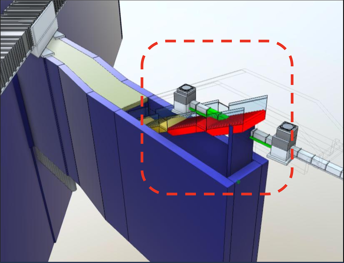
Digital models help detect early conflicts between station design and existing technical infrastructure systems.
In addition to supporting clash detection, BIM also enables control of project quantities and costs. One practical case shows that a BIM model detected inconsistencies between design documents and cost-estimate documents, thereby helping control project quantities and costs more effectively.
A deviation of only 2 m may be considered small on a drawing. However, for diaphragm wall structures that are tens of meters deep, 1.2 m to 1.4 m thick, and extend along the entire station length, this difference leads to significant changes in concrete volume, reinforcement quantity, and estimated cost.
This example shows that BIM is not only a design-support tool, but also a tool for controlling costs and data quality.
Data needs to be inherited into operation
Experience from many transportation infrastructure projects shows that most of the value of data does not lie in the design or construction stage, but in the operation stage.
A metro line may take 8-10 years to prepare for investment, design, and construction, but it will be operated for many decades afterward. However, current practice shows that data is often broken between project stages.
Survey data is created to serve design. Design data is created to serve construction. Construction data is created to serve acceptance. When a project enters operation, most of this data is not fully inherited or is no longer updated regularly.
This leads to a paradox: a large amount of data is created during the investment and construction process, but it is not used effectively during the operation stage of the works.
For infrastructure systems with lifespans of many decades, such as metro lines, seaports, and urban transport systems, this is a very large loss.
Therefore, the current trend does not stop at applying BIM in design, but moves toward building a Common Data Environment (CDE) throughout the project life cycle. In this model, survey, design, construction, acceptance, and operation data are managed within the same information system instead of existing in separate software applications or isolated records.
At that point, the BIM model is no longer simply a tool serving design,
but
becomes a data platform for asset management.
For project owners, the greatest value is not owning a complete 3D model, but the ability to retrieve
project information throughout the entire operating life cycle. Where a component is installed, what
material it uses, when it was maintained, when it needs replacement, or how it affects related systems
can
all be managed on the same data platform.
From that perspective, existing-condition data is not merely a product of survey work, nor only an input for design. It is the foundation of the entire life cycle of the works.
If the initial data is inaccurate, errors will continue to be transferred from survey to design, from design to construction, and from construction to operation. Conversely, when data is collected, verified, and properly managed from the beginning, its value will continue to be exploited for many decades after the project is completed.
This is also the condition for BIM, GIS, and further on, Digital Twins, to truly become tools for infrastructure asset management instead of only design-support tools.
Source: tapchixaydung.vn
Pageviews: 0
PORTCOAST tại Hội thảo về ứng dụng BIM, GIS trong quản lý hạ tầng giao thông
Theo tapchixaydung.vn - 13/06/2026
Sáng 13/6, Portcoast tham dự Hội thảo “Ứng dụng BIM, GIS trong quản lý...
PORTCOAST tại Hội thảo Quốc tế “Công nghệ Đường sắt Hiện đại – ISART 2026”
Theo www.utc.edu.vn - 12/06/2026
Ngày 12/6/2026, Portcoast tham dự Hội thảo Quốc tế “Công nghệ Đường sắ...
BỆNH VIỆN NHI ĐỒNG 1 VÀ PORTCOAST KÝ KẾT THỎA THUẬN HỢP TÁC TOÀN DIỆN
Theo nhidong.org.vn - 06/04/2026
Sáng ngày 26/3/2026, Bệnh viện Nhi Đồng 1 và Công ty Cổ phần Tư vấn Th...